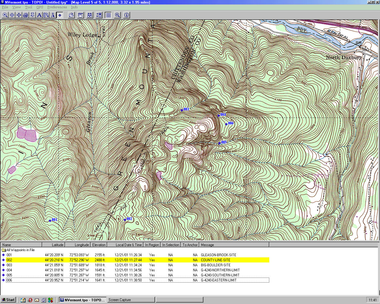
Location of Candidate Sites
Montpelier Section and the Green Mountain Club are reviewing four sites for an overnight
shelter to replace Gorham Lodge. The map below is quite large (725,000 bytes) so
while it is loading, you could read the following:
The map is derived from USGS topographical maps. The contours are probably reliable.
The route of the Long Trail and forest cover should not be relied on for navigation.
Our own observations were made on 4 and 12 November and 19 December, 2001.
We made GPS readings of the Gleason Brook and County Line sites. They are accurate
to a few feet. The coordinates are displayed in the caption of the map.
The location of Big Boulder was estimated by comparing the map to the terrain features
we saw 19 December. We paced the distance from Big Boulder to the Long Trail,
estimated the distance as 1000 feetbut figure on the possibility of a 500-foot error.
A GPS reading, a second pacing, or a timing of the hike in would be welcomed.
The location of G-4240 remains in doubt. It is, by definition, 4240 feet from the
Long Trail. We lost the markings 2930 feet from the Long Trail. Point 4 on the
map represents where we thought we were, given local terrain and the fact that
we emerged at Big Boulder. Point 5 is a guess where we should have been, given
Greg W's map. Point 5 corresponds to Greg's description of a cliff on the left
and a stream on the right. Point 6, from Greg's map, is where Route G turns east and follows a
ridgetop down to his G-H-K junction at elevation 1300 feet. Our best estimate is
that G-4240 lies somewhere between Points 4 and 5, a distance of 0.25 miles.
Directions to the candidate sites
Start at the Long Trail parking area on River Road.
- Big Boulder.
- Hike past Duxbury Window and Spruce Knob (where routine fall maintenance usually ends).
- At 2.1 miles the trail sidehills to the left into a "slot," bends 180 degrees
and continues southerly up 3 rock steps.
- At the bend there are 2 green-yellow flags for skiers. Turn off the LT and
descend 1000 feet to the east.
- The terrain flattens out. At the site is a boulder about 8 feet high and 15 feet wide.
- G-4240
- Continue on the LT beyond the turnoff to Big Boulder for 0.8 miles.
- 2.9 miles from the parking area, before a steep climb, there is a triple-blue-banded tree 25 yards on the left (east).
- Turn left follow red and blue flags 1643 feet.
- Follow the exposed ledge, dropping into a small ravine, until G-2678. This section has sparse flags but the route is apparent.
- At G-2678 there is a 20-foot vertical cliff. Flags are visible at its bottom.
- See Greg's description. You're on your own from this point on.
- County Line
- Continue on the LT beyond to the turnoff to G-4240 for 1.3 miles. This section begins with a steep climb, then follows the open ledge.
- At 4.2 miles, the trail drops down from the open ledge, crosses a small brook, into a forest of birch.
- At the brook is a triple-yellow-banded birch. Follow the brook and yellow flags to 3 banded trees at a small pool.
- Climb a few feet from the brook and in less than 50 yards is a triple-yellow-banded birch.
- To the left, about 50 yards away are 3 similarly-banded trees. This is the lodge side.
- Gleason Brook
- Continue on the LT about 0.6 miles to the Ski-around Trail.
- Just before a sharp climb there is a 6-inch rock cairn on the right.
- Turn right and follow the trail for 15-20 minutes.
- At a tree triple-flagged with orange tape, turn right and head downhill
- Within 25 yards flags will be visible. Follow them downwards, keeping Gleason Brook to your left.
- When the flags end, follow other flags left to the proposed site.
Further details are available in the reports of our hikes. They are available at
the Montpelier Section part of this website. Greg W's description
of Route G, dated April 2001, is essential to find G-4240.